
AUTHOR: Ing. Maurizio Catapano
TUTORS: Ing. Giovanni Franchi, Ing. David Marini
COMPANY: BBT SE
MASTER: Master in “Project Management in Construction Works with BIM” a.a 2021/22
La metodologia BIM sta conducendo ad una netta rivoluzione nel settore Architecture, Engineering & Construction (AEC), oggetto, negli ultimi anni, dell’introduzione costante di nuove tecnologie. Parallelamente, sta sorgendo sempre più la necessità di rendere più prestanti le strutture e le infrastrutture nella fase della manutenzione successiva.
La realizzazione di un modello informativo di progetto durante la fase di costruzione dell’opera è, oggigiorno, uno strumento attuato in modo sempre crescente, soprattutto nell’ambito delle opere coinvolte nel potenziamento trasportistico europeo. In questo nuovo scenario, per queste infrastrutture ci si ritrova a gestire una importante mole di dati. È quindi necessario avvalersi di mezzi che possano garantire la piena collaborazione tra le parti coinvolte nell’intero processo progettuale ed informativo. A tale proposito, gli sviluppi legislativi e di normativa tecnica in Europa e in Italia stanno guidando le diverse categorie professionali del settore verso una radicata applicazione della metodologia BIM.
Attualmente, la progettazione e la gestione delle costruzioni in ambiente BIM è una prassi ben consolidata nel settore dell’edilizia, grazie al compimento (nell’ultimo decennio) di importanti studi che, invece, sono ancora in corso ma procedono spediti nel campo infrastrutturale (I-BIM).
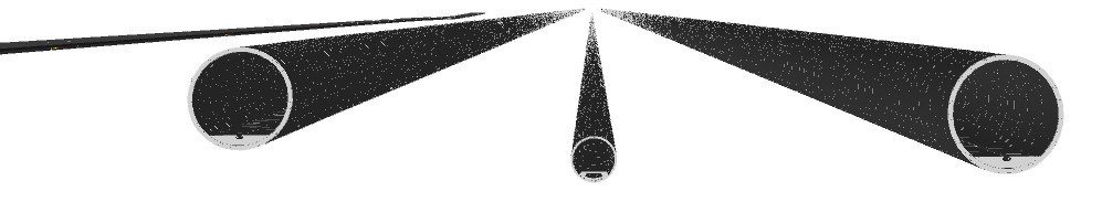
Modello As Built, da sinistra a destra: galleria di accesso realizzata con scavo tradizionale, gallerie di linea (ovest ed est) e cunicolo esplorativo realizzati tramite scavo meccanizzato.
In questo contesto si inserisce lo sviluppo BIM della Galleria di Base del Brennero, l’opera sotterranea più lunga del mondo al suo completamento, che collegherà Innsbruck a Fortezza attraversando il passo del Brennero e che costituirà parte integrante del piano di potenziamento dell’Asse Ferroviario Verona – Monaco di Baviera.
Alla base di questo studio vi è l’obiettivo di individuare un processo metodologico efficace, non solo di modellazione informativa ma soprattutto di revisione e coordinamento attraverso procedure di checking.
Il caso studio riguarda il Lotto Costruttivo Mules 2-3, il più esteso della Galleria di Base.
Attraverso la modellazione digitale, si vuole ottenere un Project Information Model (PIM) composto dai rivestimenti definitivi fruibile nella fase realizzativa, nonché, ad opera ultimata, un Asset Information Model (AIM) utilizzabile per la fase manutentiva. Tale modello informativo di progetto si basa, nella prima fase, su un As Built, ricavato dai documenti della Progettazione Esecutiva, con gli aggiornamenti intercorsi durante la realizzazione ed informazioni qualitative e quantitative degli avanzamenti eseguiti. A conclusione dei lavori, il modello riporterà l’opera così come è costruita e completo di tutte le informazioni afferenti agli elementi in esso contenuti.
L’opera è costituita da tratte scavate in tradizionale ed in meccanizzato (cioè con l’impiego di Tunnel Boring Machine), i cui rivestimenti sono caratterizzati da un adeguato Livello di Fabbisogno Informativo. In quest’ultimo sono incluse informazioni come, ad esempio, le date realizzative e WBS (Work Breakdown Structure), ma anche set documentali come specifica reportistica tecnica, geologica ed amministrativa.
Per poter fornire un modello il più possibile corrispondente al realizzato, non solo per quanto riguarda la geometrizzazione, ma anche la raccolta documentale, è necessaria una stretta collaborazione tra impresa esecutrice, direzione lavori e committenza.
I modelli locali informativi sono stati realizzati attraverso il software Revit con l’ausilio di script di programmazione visuale realizzati in Dynamo per l’automatizzazione di alcuni processi, tra cui il codice per l’estrusione dei rivestimenti definitivi degli scavi in tradizionale (in funzione delle lunghezze di getto), o anche lo script per l’installazione dei conci di TBM secondo lo schema di montaggio adottato per le realizzazioni in meccanizzato.
I modelli sono stati poi sottoposti a procedure di Model Checking ottenendo così un PIM verificato per il coordinamento. A tal riguardo, sono state studiate procedure per la verifica delle incoerenze informative, fondamentali per poter analizzare successivamente l’infrastruttura nella dimensione 4D, attraverso simulazioni realizzative day by day ed il collegamento delle tratte realizzate al programma di esecuzione dei lavori. Il checking ha coinvolto, in particolare, i codici di WBS, le date di getto dei conci e le date di montaggio degli anelli della TBM.
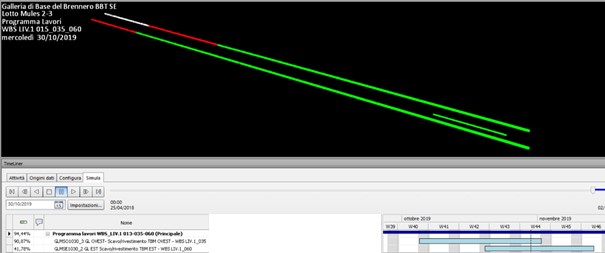
Analisi 4D dell’opera
Analizzata la fase temporale, è stato infine necessario determinare una procedura per l’ottenimento dei modelli informativi secondo il formato aperto e non proprietario IFC con la mappatura degli attributi e l’associazione di Property Set secondo una precisa Model View Definition. Disporre di un modello OpenBIM risulta fondamentale per le esigenze progettuali future, così come per la manutenzione dell’Asset da parte del gestore dell’opera.
Nel complesso, quanto analizzato può ritenersi un approccio metodologico standardizzato applicabile ad altre opere infrastrutturali sotterranee.
La ricerca di una linea guida del metodo è stato lo scopo principale del presente studio, la quale deve essere continuamente sottoposta a processi di miglioramento dato il costante sviluppo nel settore AEC e nell’I-BIM.
FOR INTERNATIONAL STUDENTS:
The BIM methodology is leading to a complete revolution in the Architecture, Engineering & Construction (AEC) industry, which has experienced the constant introduction of new technologies in recent years. At the same time, there is an increasing need to improve the performance of structures and infrastructures in the subsequent maintenance phase.
The creation of a project information model during the construction phase of a project is nowadays an increasingly used tool, especially for works involved in European transport development. In this new scenario, for these infrastructures there is a large amount of data that needs to be managed. It is therefore necessary to make use of tools that can guarantee the full cooperation of all involved parties in the whole design and information process. In this regard, developments in legislative and technical regulations in Europe and Italy are guiding the various professional categories in the industry towards a widespread application of the BIM methodology. At present, the design and management of constructions in a BIM environment is a well-established practice in the construction industry thanks to in-depth studies that have been carried out in the last decade. These studies are still ongoing, but are proceeding apace in the infrastructure field (I-BIM).
The BIM development of the Brenner Base Tunnel, the longest underground infrastructure project in the world on its completion, is set against this background. The BBT will connect Innsbruck to Fortezza via the Brenner Pass and will form an integral part of the expansion plan of the Munich-Verona railway axis.
The aim of this study is to identify an effective methodological process, not only of information modelling but above all of review and coordination through checking procedures.
The case study is about the Mules 2-3 construction lot, which is the widest lot of the Base Tunnel.
By means of digital modelling, the aim is to obtain a Project Information Model (PIM) of the final linings that can be used during the construction phase. After completion of the works, the goal is to have an Asset Information Model (AIM) as well, which can be used during the maintenance phase. This project information model in the first phase is based on an As Built model extracted from the documents of the executive planning, including the updates made during the construction and qualitative and quantitative information concerning the excavation works carried out. After the completion of the work, the model will show the tunnel as built, including all detailed information concerning all the elements contained in it.
The tunnel consists of stretches that have been excavated by blasting and by TBM (i.e. by using a Tunnel Boring Machine) which are characterized by an appropriate Level Of Information Need. It includes information such as, for example, construction dates and WBS (Work Breakdown Structure) as well as documentary sets like technical, geological and administrative reports.
In order to provide a model which most closely matches what has been built, not only with regard to geometrization but also to the collection of documents, close cooperation among contractor, construction management and contracting authority is required.
The local information models were created by using Revit with the aid of visual programming scripts made with Dynamo to automate some processes, including the code for the extrusion of the final lining for drill&blast excavations (depending on the jet length) or even the script to install TBM tubbing according to the installation plan adopted for mechanised excavations.
The models have undergone Model Checking procedures, thus obtaining a verified PIM for coordination. In this regard, procedures have been studied to check for information inconsistencies. These are crucial to analyse the infrastructure in a 4D dimension at a later time through implementation simulations day by day and by connecting the completed stretches with the construction programme. The check included in particular the WBS codes, the installation dates of tubbing rings and the assembly dates of the TBM rings. After analysing the time schedule, it was necessary to assess a procedure for obtaining the information models based on the open and non-proprietary file format IFC, with the mapping of features and the combination of Property Sets following a precise Model View Definition. Having an OpenBIM model is crucial for future design needs, as well as for Asset’s maintenance during the operation phase.
Overall, this analysis can be considered as a standardized methodological approach which can apply to other underground infrastructure projects.
The search for a guideline for this method was the main purpose of this study. This guideline must be constantly subjected to improvement processes, given the constant development in the field of AEC and I-BIM.